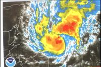
 As flood waters continue to recede across the country, the National Meteorological Service has also been keeping a watchful eye on a system that quickly developed overnight from tropical depression 17 to Hurricane Paloma.
The good news however is that on its present track, Paloma poses no direct threat to Belize. Instead it should bring heavy winds and rain to the Cayman Islands as it continues to move in a northerly direction.
Earlier today, 7News spoke with Acting Chief Meteorologist Ramon Frutos. According to Frutos because the system is still in our area, and history has shown that conditions can always change we should not let our guard down.
Ramon Frutos, Acting Chief Meteorologist
“We in Belize continue to watch very closely and we are asking the Belizean public to remain vigilant in the event that Paloma does not follow the predicted track that is being forecast that is moving towards the west northwest today then northwards tomorrow and then north eastward on Saturday and into the weekend and if it should shift a little further to the west it could have
some impacts along the coast of the Yucatan and Belize but mostly in the form of rain, rain and some showers along the coast, not life threatening and not intense enough to cause widespread flooding.”

“We did not see the need to declare the preliminary phase as yet until we see that indeed this system will be heading westwards and into and probably affect us or move towards the coast of Belize or Yucatan and could impact us with some heavy rains but at the moment that is very unlikely.”
“We had a ridge of high pressure that was sitting over the Southeastern United States and into the Gulf of Mexico over the past few days that was the system that came behind the big cold front that passed us , the cold front that came through Belize sometime ago and produced that nice cool weather that was helping in the lowering of water levels and the evaporation of water on the landscape and drying out the area. Now that high pressure ridge is collapsing, it is weakening and that has opened a path for this system to move a bit further to the north west. However a major cold front is heading its way into the gulf, it is over the Texas area and it will move into the gulf and behind this cold front we have another high pressure system building into the gulf and so the
westerlies over our latitudes will be increasing as we go into the weekend.
So that is already another indication that the prevailing winds will provide the impetus to keep this system away from the coastline and move further or keep it off shore and move it farther to the northeast.”
According to Frutos systems that develop this time of the year in the southwestern Caribbean generally move north or towards the east but, still, we should not become complacent.
Frutos says although there are only two more weeks to go before the hurricane season comes to a close there is a still the chance for another system or two to develop in our area and that is why we should remain vigilant. | 
