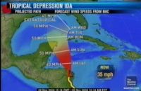
Ida is now a tropical depression gaining strength in the warm waters
of the Western Caribbean. At three this afternoon Tropical Depression Ida emerged
of the north coast of Honduras moving northwest at 7 miles per hour with winds
of 35 miles an hour. The storm is expected to strengthen. Belize remains mostly
out of the projected storm track. We say mostly because according to the computer
models, northern Belize could experience some of the outer bands of the storm.
The storm is expected to pass closest to Belize sometime on Saturday evening,
and the greatest threat at this time is flooding. Meteorologist Frank Tench
discussed the scenarios and what you should do to stay safe.
Frank Tench, Meteorologist
“The greatest threat for flood remains over the southern parts of
the country, the Toledo and Stann Creek Districts. The rest of the country,
the risk for flooding isn’t that high.”
Jules Vasquez,
“How is this flood threat fleshed out because looking at the storm track
from an amateur’s perspective, one would conclude that it is clearly steering
very clear of southern Belize. The only place that stands at any risk is the
north. So how would that create flooding events in the south?”
Frank Tench,
“Okay while the storm is a depression as it stands, during the course  of its movement over the northwest Caribbean during tomorrow, further intensification
of the storm is quite possible and you could very well have feeder band clouds
moving across the coastline during its passage over the northwest Caribbean
and these feeder band clouds generate tremendous amount of rain and therefore
the risk for flooding with the country already saturated from rains over last
weekend, that risk remains fairly high.” of its movement over the northwest Caribbean during tomorrow, further intensification
of the storm is quite possible and you could very well have feeder band clouds
moving across the coastline during its passage over the northwest Caribbean
and these feeder band clouds generate tremendous amount of rain and therefore
the risk for flooding with the country already saturated from rains over last
weekend, that risk remains fairly high.”
Jules Vasquez,
“Is there a risk for flash flooding?”
Frank Tench,
“Yes if you get very intense feeder band clouds being generated from
the system during the course of its passage over the northwest Caribbean tomorrow
flash floods are a distinct possibility.”
Jose Sanchez, News 5
“When is the danger period expected to pass?”
Frank Tench,
“I would say for the greater part of the country by Sunday, most areas
of the country should be out of the risk for any catastrophic effect from this
system.”
Jules Vasquez,
“Including floods?”
Frank Tench,
“Well that depends on how much rain we get from the system. So the
flood risk will still be I would say fairly high.”
Jules Vasquez,
“What would be your advice to citizens at home?”
Frank Tench,
“I would say continue to monitor the reports issued by the weather
service, be very careful in whatever activities you conduct this weekend because
it is going to be a rather wet weekend for most of the country, especially Saturday
and that would be my advice to the general public at this time.”
Jules Vasquez,
“As I have read in published reports, the rainfall was lower than expected.
If indeed that is the case, would that augur well for us here in Belize?”
Frank Tench,
“Yes because a fact of these storms is that the most intense shower
and rains tend to occur on the northeast and eastern quadrant of the storm and
if the storm continues on the current path it is then most of the intense showers
and thunderstorms would remain well to the east of Belize and therefore we would
be spared from the worst effects from this storm during this weekend.”
The National Hurricane Center in Miami reports that the rainfall threat
associated with Ida is diminishing over Central America. Rainfall associated
with Ida may begin to affect eastern portions of the Yucatan Peninsula on Saturday.
And while the rainfall over Nicaragua and Honduras was below projections,
it has been significant. According to reports from the Nicaraguan coast which
was slammed with Hurricane force winds yesterday morning, Ida, struck land about
60 miles northeast of Bluefields, and about 80% of homes were destroyed in nearby
Karawala, a fishing village of about 100 shacks. No deaths or injuries have
been reported. | 
