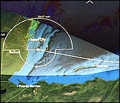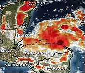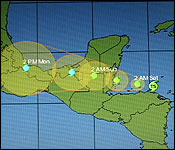

 Tropical Storm Harvey is gaining strength and heading for Belize tonight. At 6:00 pm, the storm was located 255 miles east southeast of Belize City and heading west with maximum sustained winds of 50 miles per hour.
The Government of Belize has declared a Tropical Storm Warning for the entire coast of Belize. The country is in the Red Two Phase of the National Emergency Warning System and NEMO has been activated and on high alert.
The center of the storm will skirt past the Bay Islands of Honduras tonight and make landfall on Belize sometime tomorrow as a Tropical Storm.
We asked Chief Met Officer Dennis Gonguez - what will be the windspeed when it touches down in Belize:…
Dennis Gonguez, Chief Met Officer
 "As it heads closer to us and approaching landfall tomorrow afternoon we expect the winds to further increase to near 60 miles per hour. So we are looking at a moderately strong tropical storm affecting us tomorrow."
Jules Vasquez
"Where is it expected to make landfall?"
Dennis Gonguez, Chief Met Officer
"The present track projections put in pretty much in the vicinity of where Richard made landfall last October. So it seems it's headed in that general direction. Just near where landfall will be we expect winds of 60 miles per hour and as it heads further north the winds should drop off to about 40 miles per hour in Belize City and then further north and south the winds will drop off to about 30-35 miles per hour in Orange Walk and Corozal Districts. Landfall will be shortly after mid-day to mid-afternoon tomorrow. It seems we will be out of fear by the evening. By Sunday we should start to see some clearing up in weather conditions in the morning."
Jules Vasquez
"Now we know that Hurricane Richard was only a category 1 storm. What should we expect from this one in terms of it being a tropical storm at landfall?"
Dennis Gonguez, Chief Met Officer
"Well Hurricane Richard was substantially stronger than what Tropical Storm Harvey is forecast to be and so we should not expect as much destruction as what happen last year with Hurricane Richard."
Jules Vasquez
"What is the threat to property and physical infrastructure? What should people be on the lookout for and what should people do if they feel they live in a fairly vulnerable structure?"
Dennis Gonguez, Chief Met Officer
"If you are of the opinion that your structure cannot withstand the wind speeds that I am speaking about then you have to look for a safe shelter."
Of course, the storm force winds are one thing, flooding is quite another, particularly in the south.
A NEMO advisory issued this afternoon says that those living on Coastal communities, particularly Belize City, Dangriga, Mullins River, Gales Point, Monkey River, Silk Grass, Independence, the Placencia Peninsula, Seine Byte, Punta Negra, Hopkins and surrounding villages that normally flood and get cut off due to flooding are advised to move to higher grounds. Including communities in the Toledo District such as Midway, Corazon, Boom Creek, Bladden, Swasey and Golden Stream. Small communities along the Coastal Road and the Old Northern Highway are also advised to move to higher ground.
As for shelters, a 6:00 pm advisory notes that NEMO is making final preparations if the need arises to open shelters as follows: in the Belize district, in villages from along the old northern highway, in Belize city and Gales point.
In the Cayo district: shelters will be open if the need arises in Belmopan and surrounding communities; in the Stann Creek district: Hopkins, Dangriga, the Placencia Peninsula, Independence and communities along the Hummingbird highway down to Monkey River in the Toledo district. Again, those shgelters will be open, quote, "if the need arises."
The advisory warns that those communities as well as San Ignacio and the surrounding villages are currently in the projected path of Tropical Storm Harvey including all cayes going south from English Caye to South Water Caye.
According to the advisory, "All NEMO staff is on full alert and key national and district committees are activated in the event…a rapid national response is required. Public Officers are advised to be on standby to report for duty as Shelter Wardens as the need arises.
| 
