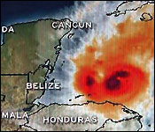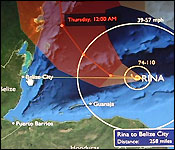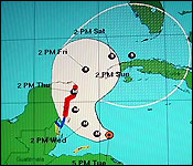

 Tonight Hurricane Rina poses a significant threat to Belize. It is a slow moving, category two storm with maximum winds of 110 miles per hour and it is 255 miles almost due east of Belize City.
The problem tonight is that - while forecasters continue to say the storm will take a sharp northwesterly track - this afternoon, Rina defied those predictions, and started heading west - which - if it were to continue on that track - would be straight towards Belize City.
After that 3:00 pm advisory, we asked Chief Met Officer Dennis Gonguez what the westerly track means - and what kind of precautions you should take.
Dennis Gonguez - Chief Met Officer
"At 3 pm today hurricane Rina was located near latitude 17.4 north and longitude 84.3 west, that location is about 250 miles east of Belize City. Rina has strengthened and now has wind of 110 mph. it's almost a major hurricane almost a category three hurricane. Developments are that Rina is now on a west worth track at about 3 mph. Still forecast to make a more northwesterly track and then a more northerly track on Thursday. However at the present time it continues on a slow westerly track at 3 mph.
 "We have to place close attention to it. During the course of tonight we have to keep monitoring hurricane Rina to see whether it assumes a more north westerly track during the course of tonight. If it continues travelling towards the west then we are in for some major problems. it's east of Belize City at latitude 17.4 north and Belize city is 17.5 north so it's almost directly east of Belize City and like I said about 258 or 260 miles east of Belize City. Because it's over favorable conditions - it's over a pool of warm sea surface temperatures that is favorable for it to intensify further to be a major hurricane a category 3 hurricane during the course of tonight."
"We should be paying close attention during the course of tonight with the motion of this system to see whether it takes that more west north westerly track and if it doesn't then our preparations must be completed tomorrow to safeguard life and property."
"If it continues westerly track land fall will be just north of Belize City, however the most of the forecast models are indicating a north westerly turns during tonight and tomorrow morning, and that's why we have to keep monitoring during the course of tonight to see whether turn materializes."
"Rina is a potentially dangerous hurricane and we should be paying close attention to what it's doing presently and what it's projected path is for Rina, because if it continues on a westerly track it could create major havoc for Belize."
A hurricane watch is in effect for the coast of Belize from Belize City to the northern border.
Again the storm is 255 miles due east of Belize City and Tropical storm force winds extend outwards 140 miles while Hurricane Force Winds extend out 30 miles from the center. A turn to the west northwest is expected tonight - and we'll be watching closely for that.
NEMO says Rina is expected to become to major Hurricane within the next 24 hours - although with winds presently at 110 miles per hour, she is fairly formidable as is.
Later on in the newscast, we'll show you how evacuation efforts on San Pedro were going today.
| 
