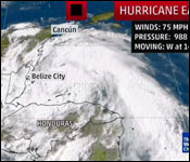
Tonight, Belize is bracing for the force of a large Category 1 hurricane and the two red flags with black centres flown above each other, means that Hurricane conditions are fast approaching.
According to the latest update from NEMO, Earl will make landfall on Belize at about midnight – but the first Tropical Storm force winds will reach Half Moon Caye within half an hour, and San Pedro by 9:00 pm.
Now the most important fact about this storm right now is that the eye is wobbling just a bit, so it's hard to say just where on the Belize Coast it will make landfall. It's important to know where the eye will land because the storm force winds are in the quadrant just north of that. So wherever the eye lands, the brunt of the storm force winds will be felt to the north of that.
And at 5:00 pm, NEMO announced, quote, "The predicted path/impact areas HAVE CHANGED to north of Belize City." The bulletin goes unto say, quote, "The main impact zone now seems to be shifting to Belize River Valley area villages such as Willows Bank; Rancho Dolores; Isabella Bank; Double Head Cabbage; and villages in southern Orange Walk such as Guinea Grass, August Pine Ridge, San Felipe, Indian Church and parts of Corozal." End quote.
This is important, because earlier today the models were suggesting that it would make landfall in the south near Mullins River or Gales Point, but that has changed. That means that if it stays on this track - and that is a very big if – Belize City would not get the brunt of the storm force winds – which, again, are concentrated to the north of the Hurricane. But, truth is, it's a storm, and until it hits, no one can be certain of what Hurricane Earl is really going to do until it happens.
And so that's why NEMO is saying tonight that you have to be prepared for the winds, rain and flooding of a serious storm no matter where you live. We all remember Hurricane Richard in 2012, which – like Earl – was a category One Hurricane – and it did damage all the way into the Cayo District.
According to NEMO, this is how Earl will approach Belize: the outer atolls will be affected at about 7:00 p.m. tonight. And then, San Pedro, Caye Caulker, Corozal, Orange Walk and Belize City will experience 40 mph winds at about 9-11:00 p.m. At midnight we Hurricane force winds will sweep in over that the projected path. At 1:00 a.m. hurricane force winds will be over mostly the Northern half of the country.
So, to be clear, Earl will make landfall in Belize tonight or early Thursday morning with winds of 75 miles per hour. The storm will generate rainfall of 8-12 inches over Belize with possible higher amounts. NEMO warns, quote, "We will experience strong winds blowing as fast as 70 or more miles or per hour, heavy rainfall; storm surge; flooding along the coastline; trees blown down; weak house and structures will be damaged or destroyed; loose objects will become projectiles, power outages and disruption to water. As the system approaches expect light winds, then heavy hurricane like winds, thereafter there will be a calm as the eye passes; thereafter we will experience very strong winds then the winds will get weaker and eventually die off." End quote.
|

