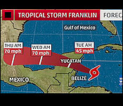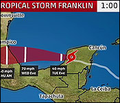


 Last night, in our coverage of Tropical Storm Franklin, we told you how the 6th named storm for this season might end up not affecting Belize. That's because Franklin started shifting away from Northern Belize a few hours before it made landfall.
So, when the storm finally came ashore on the south - central Yucatan Peninsula, Belize - from Corozal, to San Pedro, to Orange Walk - was completely spared, except for a few scattered showers. Today, Daniel Ortiz took a closer look at the storm which faked west and went north. Here's his story:
Daniel Ortiz reporting
For most of yesterday, Belizeans diligently prepared for the possible landfall of Tropical Storm Franklin. The forecasts say that it would make landfall near the Belize Mexico border, and so a Tropical Storm warning was activated from The Northern border to Belize City. Yet, even though the authorities locked down the northern heal of the country to brace for a storm, none came to Belize.
There were no real effects of Franklin felt in this country. In fact, most people went to bed with very little rainfall, if any. The Chief Meteorologist says that the relief came as a consequence of a last minute shift in the storm's path.
Catherine Cumberbatch - Chief Meteorologist
 "Tropical Storm Franklin had a track that it was traveling west northwest, with a projection to make landfall just north of the Belize Mexico Border. However, what happened at around 6 p.m., that track changed. The motion - it took up a motion going - rather from west to northwest, it took up a more northwest track, and by taking the northwest track, it ultimately meant that Tropical Storm Franklin would be farther away from the country. And that is exactly what happened."
So, while Belize was spared, the storm slammed into the Eastern coastal communities along Mexico's Yucatan Peninsula. Franklin's eye landed near to the Mexican town of Pulticub, in the State of Quintana Roo. Pulticub is approximate 63 miles northeast of Chetumal, and 78 miles south of Tulum - as the bird flies. Nearby vacation spots of Cozumel, and Playa Del Carmen also felt the force of the storm's 60 mile per hour winds and rain.
Catherine Cumberbatch - Chief Meteorologist
"At around 10 o'clock last night, Franklin made landfall at the East Coast of the Yucatan Peninsula, just out of Punta Allen, it made land fail. It made landfall as a tropical storm, with winds up to 60 miles per hour. The impact as it pertains to Tropical storm Franklin, on Belize, was minimal. As I said from the beginning, we were expecting most of the feeder bands, and the stronger of the feeder bands to hit over the north of the country. But as I said before, as it shifted to a northwest track, rather than west to northwest track, that kept the system farther away from us, which is actually a blessing for us."
Now that the storm is no longer a threat to Belize, what were its actual effects on the country?
Catherine Cumberbatch - Chief Meteorologist
"Tropical Storm Franklin was expected to produce 3 to 6 inches of rain, that's from the system, and Belize was supposed to be impacted by the spiral bands. Some spiral bands did impact Belize earlier. Like in Belize City, earlier during the day, we had spiral bands cause rain almost 1 and a half, to almost 2 inches of rainfall in Belize City and at the Airport, and also later down south, due to the feeder band from the Tropical Storm. They got only an inch of rainfall. In the extreme north, we got minimal rainfall."
Nemo reports that 330 persons from Corozal, the Cayes, and Belize City went into hurricane shelters. Approximately 2,157 persons volunteered to relocate from the islands to the mainland.
In Mexico, news reports are that the damage has been minimal. There are downed trees, and the power was out in some areas, but there are no reports of major structural damage or flooding. There are concerns that the rain associated with the storm could still cause flash floods, however.
The storm has now crossed over the Yucatan Peninsula, and it is back in open water in the southern Gulf of Mexico. After crossing over land, it has weakened to 40 miles per hour.
Weather experts believe that the conditions are favorable for it to regain the strength, and by late Thursday, early Friday, it could make a second impact in Mexico as a stronger storm. The forecasted path is for the coastal communities between Tampico and Veracruz.
|

