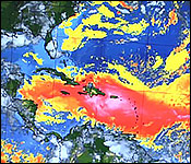
 It's been two days of intense cloud cover and ashen grey skies. But it's not just Belize that's suffering. In fact, we're getting the least of it with other Caribbean nations acting as a buffer zone.
And while the ugly weather is certainly a buzzkill it's an extreme version of a phenomenon that's vital to the global ecosystem, and, it might even act as a brief respite from hurricanes.
This afternoon Cherisse Halsall headed to the MET office to find out what we can expect from the lingering dust cloud.
Every year tons of sand from the Sahara desert are kicked up by dust storms, blasted high into the sky, and carried across the Atlantic ocean on wind currents. And while it's a yearly event, the 2020 version is much heavier:
Ronald Gordon, Deputy Chief Meteorologist
"The event that we're experiencing is much more intense than we have seen over the past several years. I've looked at records and it shows that this is probably a record year in terms of this particular event."
"So what happened in this particular case is that we had more intense than normal dust storms over the African continent and apart from that the easterly jet that would normally pick it up had diminished for a while so the dust was left there in the atmosphere and eventually when the jet did pick up back and those strong winds picked up and came across there was an intense amount, a lot of it."
And once that overload of dust reached the Caribbean it caused the intense cloud cover and "hazardous" air quality from which Caribbean nations are still reeling.
Reporter
"We see our counterparts in the Caribbean really suffering through this, is there any reason that we would get a milder case of the dust storm than they do?"
 Ronald Gordon, Deputy Chief Meteorologist
"It is quite likely the case, they are closest to the source so they would really be receiving the brunt of it whereas on our in it would have already dissipated a lot by the time it gets here so we don't expect it to be as severe over us as it is in that area."
It's a sandstorm that coupled with COVID gives the pessimists among us a positively apocalyptic vision. But officials at the MET say it won't last very long.
Cherisse Halsall:
"So what can we expect over the next few days until this dissipates?"
Ronald Gordon, Deputy Chief Meteorologist
"It is forecast to continue throughout this week into next week, however, the models are indicating that the intensity will decrease by the weekend."
So the worst of it should be today, tomorrow, and by Friday we'll start seeing a decrease. It will linger around but not as intensely as we're experiencing it now.
Cherisse Halsall:
"Is there any way this could contribute to staving off hurricanes this season?"
Ronald Gordon, Deputy Chief Meteorologist
"For the time being.So we don't expect the dust to last throughout the hurricane season but at the moment with that amount of dust it will suppress hurricane activity."
"So for the time being within the tropical atlantic and the caribbean development of tropical systems is unlikely, however, I must caution that this is only a temporary situation and we are still forecasting the season to be above normal in terms of activity."
As you heard the worst of the weather will occur between today and tomorrow with the dust cloud dissipating and traveling stateside by the weekend.
| 
