 A week and a half ago, we told you about the very weak and disorganized weather system threatening the Eastern Caribbean.
That low-pressure system turned into Tropical Depression 9, and eventually, it became the deadly Category 4 Hurricane Ian that devastated Cuba and portions of the US State of Florida.
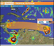
And tonight, percolating in the eastern Caribbean are the makings of another possible storm that could affect Belize. This one is now known as "Invest 91L", and it's in a similar geographical location as the previous low-pressure system that turned into Hurricane Ian.
And once again, Belizeans and other citizens of Central America and the Caribbean are keeping a close eye on this weather system since its forecasted track brings ti towards the isthmus.
This afternoon, we spoke via telephone with Ronald Gordon, the Chief Meteorologist, about this new tropical threat to the Caribbean. Here's what he had to say about the possibility that this system may affect Belize:
Ronald Gordon, Chief Meteorologist
 "We are closing monitoring this broad level of low pressure which is currently a few hundred miles to the east of the Lesser Antilles. The system has a high chance of becoming a tropical depression within the next 2-5 days. It is moving westward at about 15 miles per hour. There was a hurricane hunter mission earlier this afternoon that went into the system. It did not find a close circulation and also it did not find that it was well organized, in terms of the center. There is still some strong upper-level winds that are currently hindering the system from becoming organized and developing. However, we expect that those winds will decrease within the next few days and conditions will become more favourable for the system to intensify and possible to become a tropical depression and tropical storm provide it moves far enough from the coast of South America, but if it moves further to the north of the coast of South America - that would also be a factor favouring intensification."
"In terms of how this system could impact us, its way too early to say and the current forecast from the different models - some models having it going over Central America south of Belize over maybe Honduras or Nicaragua. There are few models that brings it over us and there a few that take it north of us. So there is a lot of uncertainty within that long time frame which is about late this weekend into early next week if it will be near us and so we will be monitoring it very closely to see whether it develops and once it develops then the models will likely consolidate on the forecast track that it will take."
"This is one we need to monitor very closely and even if it takes a southerly track out of us, there is the potential that it could impact us with heavy rainfall later on into the early part of next week. So it is a system that we are not going to take for granted and we will be monitoring very closely."
"The most important thing is for persons to be on the alert. The hurricane season doesn't end until November 30th and with a system entering the Caribbean its always something that we need to be very cautious of and aware of."
As you heard, a hurricane hunter mission was carried out this afternoon to investigate the low-pressure system. It found that "the system did not yet possess a well-defined circulation center…and now the projection is that a tropical depression is likely to form over the next several days if the system remains over open waters. The National Hurricane Center in Miami wants that, regardless of development, heavy rainfall with localized flooding,
as well as gusty winds, are expected over portions of the Windward Islands, northern portions of South America, and the ABC Islands during the next couple of days.


