And while the communities of Calla Creek, Bullet Tree and to some extent Succotz
are the most affected, that is only a part of this phenomenal bout of rains.
A gradual decrease in showers is expected over the next few days, but the rains
are expected to continue until Wednesday.
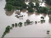
But that says nothing of the floods, which could be reaching Belize City on
Thursday. The Hydrology Unit reports that we should expect widespread flooding
in northern and central Belize while waters are receding in the south.
In the north, specifically, the Blue Creek area of Orange Walk District the
water level has already surpassed the Mitch flood stage in 1998. The Hydrology
Unit is advising all residents living in low lying areas to monitor and be ready
to move just in case there is a need to evacuate.
In the central region, the Belize River is already swollen and expected to
rise more as the waves of flood waters head in its direction. The Northern Highway
is also being closely monitored as parts of the road are expected to flood.
Two areas of concern is the stretch of road by Williamson sewing factory and
Crystal Auto Rental just past the Haulover Bridge.
According to the Hydrology Unit the flood waters should reach Belize City by
Thursday and if its arrival coincides with a high tide you can expect heavy
flooding in the city. That’s what happened Saturday at around midnight
when heavy rains came down and coincided with a high tide to produce significant
but short lived flooding in the city. Residents in some low areas had to be
evacuated.