In the rainy season, it’s common to see the Macal river in western Belize
with a reddish brown color, the product of soil runoff coming down from areas
upstream.
But this year, the river appears slightly orange, almost the color of clay,
or chocolate milk. Environmental watchdogs in the area say they know what the
problem is and they say it’s the Chailillo dam.
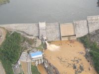
Indeed, aerial pictures circulated by some of those environmentalists show
that the water accumulated at the head of the dam’s lake is clear, but
the water being pumped out through what’s called the level outlets is
a turbid, clay color.
BECOL’s Operations Vice President Stephen Usher told us that it’s
accurate to say that the dam operations are producing the particular reddish
brown color in the river.
Usher explained that while the water on top of the lake is clear, at bottom
it’s all silt. The turbines pump their water form the bottom, so inevitably
what they discharge will have that soil color.
And this is BECOL’s point: this is the first time they’ve gotten
so much silt and Usher says it’s because of unregulated deforestation
and Xatero activities upstream that have degraded the forest on the river banks.
Because of that the soil loses its integrity and during flood spells like this
it rolls down into the river.
Usher says it will be a while before it clears up because they are still getting
heavy rains; he adds that they even got a flash flood recently but the communities
downstream were not affected because it was absorbed by the dam.
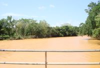
So does this pose any health risks to communities along the river? Seeing this
picture taken today at Branch Mouth where the Mopan and Macal rivers meet, that’s
a legitimate question.
According to Chief Environmental Officer Martin Allegria the iron levels in
the river were elevated when they tested it two weeks ago. But he says it poses
no health risk because iron is not classed as a heavy metals. BECOL’s
Usher says their tests show no elevated levels; in fact he says the iron readings
are low.
They do agree though that deforestation and degradation of watershed areas
accounts for the excessive silt buildup.
Area environmentalists disagree; they say that it cannot be blame don Guatemalans.
They argue that Guatemalan settlements are in the Mopan watershed, not the Macal
watershed. And as is visible at Branch mouth, it’s Macal, not Mopan that’s
carrying all the silt.
All parties agree that it will be some time before it clears up.