 As we showed you earlier, Tropical Storm Alex hot Belize but did not create much surface damage. Early Predications indicated that Tropical Storm Alex was to make landfall in Northern Belize or the Yucatan Peninsula. But those projections changed rapidly on Saturday afternoon as Alex shifted direction - heading westward - directly towards Belize City. But where did Alex really make landfall? That is a question many Belizeans might be wondering about - because it sure didn't seem like it happened in the city. Today our team headed out to the Met Office to get that answer:..
Dennis Gonguez- Chief Meteorologist
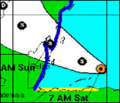
"Well I feel sure that tropical storm Alex made land fall just to the north of Belize City, so our indications are that the central of tropical storm Alex passed north of Belize City. This is the track of tropical storm Alex and we can see the repositioning just about here at 3:00 pm on Saturday, it was originally heading in a west northwest track and suddenly, there is this jump here that's where the reposition of the centre just offshore Belize and from there land fall was brought

 to Belize City and then it continued on a west northwest track. Land fall was 5:30 or between 5:30 and 6:00 pm, it started at about 5:30 pm and finish some minutes after 6:00 pm. The pockets of strongest winds that the aircraft found were in the south and the southeastern quadroons of the systems so that wouldn't have had any effect on Belize City itself. It would have been out to sea over the outer atolls of our Country. The models were indicating that the systems would have moved somewhere between near Chetumal area, it would have made land fall near Chetumal, but on Saturday at 3:00 pm when the reconnaissance aircraft came out of the system there was relocation of the center to a more westerly track at that time."
According to international news reports Tropical Strom Alex caused four deaths on Central America.
Tropical Storm Alex has now regained strength and is now located in the South Central Bay of Campeche Mexico.
But the storm's after effects are a continuing story in Belize.
This evening the National Emergency Control Management Organization sent out a press release stating there is a flood warning for all rivers of Belize.
Current flooding situations are: the Rio Hondo river levels at Blue Creek, Douglas and San Antonio are rising slowly.
At The New River water levels are rising slowly at Tower Hill and Caledonia.
The Macal River Reservoirs levels are below spillway at Chalillo, Mollejon and Vaca. While levels are normal they are rising near Chaa Creek and San Ignacio.
At San Ignacio water level remains above the low lying bridge. The Mopan River near Benque Viejo Town is rising.
On The Belize River levels are below bridge and rising near Iguana Creek. On the Crooked Tree lagoon, levels are below the causeway and steady. At Double Run, river levels are rising.
Downstream to the Belize River Valley, river levels will continue to rise slowly. Near Maypen and Double Run, levels are rising. Sibun River levels are rising near Jaguar Par, while at Mullins River, the river level are slowly rising. North Stann Creek is rising near Middlesex and rising rapidly near Hope Creek.
Kendal on the Sittee River is rising and below the low level bridge.
And in the city Residents of Belama Phase 3 and 4 are advised to remain vigilant as river levels may rise.
NEMO officials say they remain on alert and are monitoring the potential flooding across the country.