On Friday and Saturday Belizeans from the south to the Belize district were tense - awaiting the arrival of a storm - we didn't know if it would be a hurricane, a tropical storm, or a depression. Thankfully by midday on Saturday - without most of us knowing - the worst was over.
So the story tonight is that Belize was spared, again. No lives were lost, no significant property damage, no infrastructure disabled…heck, the Kendal bridge didn't even flood!
Indeed, we were lucky - as Monica Bodden found when she went south on Saturday:…
Monica Bodden, Reporting
 On Saturday morning Matthew moved onto Belizean territory as a tropical depression at about 11:40 - near the Placencia Peninsula.
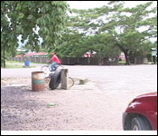
But we were just across the lagoon in Independence Village - and it wasn't even raining. And even though the trees were swaying slightly - people were just hanging out as if it was any other Saturday.
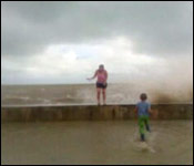
The strongest winds were concentrated north which was centered in Belize City. There was a tremendous storm surge as water rushed over the seawall - and winds of up to 30 miles per hour could have been felt.
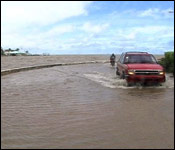
In the south, the greatest threat was to the Kendal Bridge where the fat and full Sitee River raised right up to the deck, but never above it -and the bridge never once went under.
In Pomona Village - this second phase flag - mounted on this police station - alongside a Belize Flag was drying out in the early afternoon sun.
By 3:15 on Saturday afternoon - with Matthew downgraded to a Tropical Depression - NEMO declared an all clear.
7news was at the command center in Belmopan when the announcement was made
Hon. Melvin Hulse, Minister of NEMO
 "Because the tropical storm Matthew no longer exists, came on land during the course of the day and got downgraded to a tropical depression and the majority is now outside of our country, we can now declare an all clear state. That is what we have just done, so all clear state means we now deactivate the national component of the organization NEMO and we come back to the department NEMO in which we now focus on a flood alert."
But even though the storm has passed - Hulse warns - serious flooding can be expected in the days to come.
Hon. Melvin Hulse, Minister of NEMO
"As we anticipate with the constant volume of rain that both this country and Mexico is getting and Guatemala is getting NEMO will now spend the next week on a daily basis monitoring and being alert for potential flooding that we anticipate to come from about 9 of our rivers in our country. The heavier waters come out of both from Mexico and Guatemala so with the rains that are falling in Chiapas, Mexico we are really vigilant and alert with Rio Hondo and the old Belize River. The old Belize River do have a great impact on the Orange Walk town, the Louisiana area, the Trio area. We are also fortunate and I use that word carefully because TD 16 showed us where can flood when serious floods come up. The Albion islands, San Roman, Douglas, Santa Cruz, San Antonio... What we will be doing now is stationing people and boats in these key areas to be alert as any change of the rivers, so up in the north we are looking at old Belize river and the Rio Hondo. Out in the Cayo District/Belize River Valley we are looking at the Mopan, the Macal and the Belize New River. Basically Belize New River is the product of the Mopan and the Macal so we will be alert up from the border of Arenal at the bridge at Clarissa Falls we will be monitoring, up at Cristo Rey and Macaw Bank for the Macal. We monitor the dam on a constant basis; Chalillo and Molejon to watch them because they are already over spilling, so we watch that and we monitor the Sibun River because of the impact down river past Democracia. We will be monitoring the north Stann Creek River that has an impact at Middlesex; normally impacts at mile 20 on the Stann Creek valley road; impacts on Melinda Forest Station and eventually ends up in Dangriga. The Sittee River or Kendal as you all normally refer to it impacts on the village of Sittee River so we are watching that and also we are looking at the Moho River that has an impact on Blue Creek, Santa Ana and those areas there."
According to Hulse - Belizeans have become more vigilant -taking the necessary precaution in times like these.
Hon. Melvin Hulse, Minister of NEMO
"I see it more and more Jules that we say 'warning,' people start to make their own evaluation. A lot of people quietly with no fanfare just cancel trips and they are doing it. We are more becoming a more knowledgeable nation and I think what is helping us surprisingly is the computer. More and more people do go online, and the text each other and I think this expanded communication might have its bad points and it does but it also has its benefits and it is helping. This one twitter that one; it does help. Everything that helps us to get people out of danger I accept readily."
So far no flooding events have been reported.
But that is only part of the story. Later on in the newscast we'll show you where the storm did hit the hardest and that was Placencia at about 8:00 on Saturday morning. We'll have extended images of that and an interview with the village chairman coming up later on in the newscast.
But before you breathe that sigh of relief - there's a disorganized area of cloudiness and thunderstorms over the northwestern Caribbean sea - which is that area southeast of Belize - and meteorologists say that has a 40% chance of turning into some kind of storm system. We'll tell you about that in the weather report which is coming up.