 You may not know what GIS is, but the Geographic Information Systems are critical planning tools that is used in everything from archaeology, to urban planning to utility management.
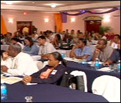
This week, ESRI, the leading Global software company dedicated to GIS is in Belize this week with a vision, it says, aimed at developing GIS technology in Belize. ESRI, has teamed up with the Land Information Center and Trimble Navigation to host the First Annual Belize GIS User Conference and Exhibition, and by all accounts, interest was high amongst Belizean companies and government departments, as was evident by the huge turnout at the Best Western Belize Biltmore Plaza.
Jim McFadzean was there, and has this report.
Jim McFadzean Reporting
It's not new technology, far from it, while many of you might not be familiar with the term GIS, there are millions of people using it already in their everyday lives.
Simon Thompson, Facilitator, ESRI
 "Everybody can use this technology, it starts off from being free online on the web, on smart devices like the iPhone, iPads, Androids. The benefits of this is bringing information together, so GIS is about taking base information, the knowledge, people working on the reef or in the citrus forest or Belize Natural Energy or BEL and bringing that information and making it available as maps or analytic reports and output."
Field crops, orchards and tree plantations are complex systems that require continuous monitoring. Right here at home GIS technology has been a godsend for the Citrus Growers Association in their battle with the pesky fruit fly, and now the damaging disease known as citrus greening.
Davis Marshall, IT Officer, CGA
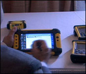
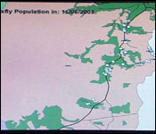 "We are using the technology to track the traps where the med flies are. What happen is that we use the technology that we use these GPSs and we use an ARGIS software to track where the traps are and to track the amount of flies that the traps catch. If you look at this laptop right here, it's showing an animation of all the traps and its showing how many traps were caught in a week. If its white that means there is no flies, if its green means the infestation is going up, if its red that means that that trap has a high infestation and the area needs to be sprayed."
So important is the technology to this country's development, that some of the most critical government, NGO's and private sector organizations, turned out to this first ever GIS sypmposium. That's because Governmental agencies can monitor natural resources to ensure regulatory compliance and manage risks from natural disasters.
Jim McFadzean
"Give us an example about how your technology can benefit a company here in Belize."
Adolfo Gomez Astua, Commercial Manager, Geo Solutions
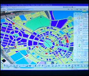
 "Well you can use it for mapping, for location your clients, to analyze visitation, need to extract some classification, 3D analyses is possible with tis technology."
Loretta Palacio, Mg. Dir., Total Business Solutions
"We have a very wide reach of fields that are being represented here today. What we are doing is inviting Belizeans to share in the vision of utilizing geographic information systems to help with the development of Belize. To help companies, organizations achieve their strategic objectives. We have information systems in our offices, most of us, all of us have data but its not geographically enabled if I could say that. So it's not reference geographically in the system. We want
 Belizeans, everybody and I am not saying companies, students, everybody to come on board and lets share in this vision of utilizing GIS to develop Belize."
The benefits of GIS are endless, including keeping track of truck drivers their speed and location, whilst monitoring the state of perishable goods in transit.
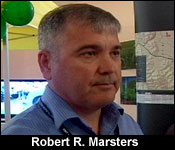
Robert R. Marsters, PMP - Director, GeoDecisions
"Some of the things that we've done for the track and trace in particular is not only to monitor where drivers are but also get information back about those drivers. Are they speeding? Are they using their seatbelt? Are they in a place where they are supposed to be? So not only do you get a report card of individual drivers but you also get report cards on the vehicle and on the fleet."
Jim McFadzean
"As in the contents in that vehicle for example if they are delivering products that are perishables."
Robert R. Marsters, PMP - Director, GeoDecisions
 "Right, depending on the device that you have, you can get just the position of where that vehicle is but more importantly you can get information about say humidity of our cargo, the temperature of the cargo or whether someone actually tries to get in and all that is in real-time going through either your cell phone. Network or in remote areas though satellites."
Tracking drivers, their location and speed at any given time of the day might be one very useful aspect of this technology both government and private sector could take advantage of, in reducing wasteful spending, whilst increasing productivity, not to mention saving lives on Belize's dangerous highways. Reporting for Seven News, I'm Jim McFadzean.
The two day Conference and Exhibition concludes tomorrow evening at 5. So for those of you who would like more information on Geographic Information Systems, you still have time to get a peek at the exhibit which is free and open to the public.