 This morning, Belize City residents woke up to a dense haze hanging over the city - and the ubiquitous smell of smoke. Most thought the dump was on fire again, but that wasn't it. According to the MET office, it's most likely the result of forest fires in the north and northwest of the country. He says the smoke was brought in by a light land wind and held in the first few hundred feet above the earth's surface by what's called a "shallow inversion layer" which tends to trap the smoke.
The broke up by noon and northeast winds pushed the smoke away.
But it has been a very active forest fire season. And according to experts, that's partly because Hurricane Richard damaged broad areas of the forest, leaving ripe fire conditions.
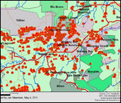
Environmentalist Jan Meerman compiled this map showing the forest fire hotspots for 2011 in the Central area of the country. Every triangle and hexagon represents a forest fire - the triangles for the active fires in May.
He estimates that in the Belize River Valley - which was very damaged by Hurricane Richard, approximately fifty thousand acres have burned. He suspects that these are largely the result of mis-managed agriculture fires that escaped into the hurricane damaged broadleaf forests which have little or no resistance against fire.
In the Hummingbird Highway Area which was also damaged by Hurricane Richard, 8,100 acres burned.
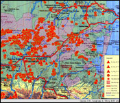
And in the Mountain Pine Ridge Area where the fires were mostly caused by lightning strikes, 26,000 acres burned.
But most of those Pine Ridge fires are history after rains yesterday - as this satellite image shows - those fires have substantially subsided.