
 Last week we told you about cases of land title theft. The fact is that all those cases of fraud were perpetrated in the Stann Creek district which still relies largely upon what's known as the deed conveyance system rather than the title registration system - which is far less susceptible to fraud.
The move to the Registration system started over 30 years ago in 1977 - and three decades later - it still has not gotten to those titles in the Stann Creek and Toledo Districts.
So, those are the ones being preyed upon by land fraudsters. And while that changeover from the deed system is on some infinite timeline - the Registration system is getting a major boost with an urban mapping project.
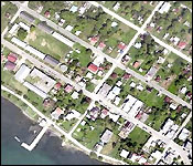
It's a part of stage three the Land Management Project - and the technical consultant explained how though specialized aerial photography it will provide something like a visual fingerprint of very parcel of land, every installation and every street in every urban area across Belize.
Lindsay Belisle, Tech Advisor, LMP III - MNRE
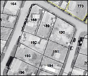
"With this fly over the maps produce will be auto rectified or will be corrected so that you have any kind of shadows or any kind of leaning of buildings or any kind of distortion will be taken or the perspective center of these photographs
 will take so you will have a true bird's eye view. With that now you can go into the photograph and you could identify people property. You could identify the buildings that are on the property but what we do with these maps or photos - we overlay the existing cadastral plans or the old maps that were made of the town and we super-impose them on these new aerial photograph. So that help to bring the map into the new national grid in the correct geographic position on the earth and when you super-impose this map over the aerial photograph you will see that sometimes building are in roads and the parcel boundary would cut a house in two."
Jules Vasquez
"That is a mapping error."
Lindsay Belisle, Tech Advisor, LMP III - MNRE
"It's not a mapping it's an occupation error. People on the ground occupy the land differently from what the map has. It's a big camera that is anchor into the plane. t has gyroscopes that if the plane tilts, and tips and swings that automatically adjust itself to keep level so that you get in true bird's eye view. With every exposure it connected to the satellite to give you exactly where that picture was taken on the earth. This will help you to be able to get you a map of your property that is in the correct position. What this will also do - it will allow that you get the correct parcel of land. So it will help secure your title."
This year's aerial survey focused on five urban areas.
Belisle is also a former Permanent secretary in the Ministry of Natural Resources and he shared some idea on how the Deed Registration system can be tightened.
Jules Vasquez
"The government is the repository of the land titles and so is confidence keeper because I go to sleep at night in the confidence that my title is secure and indefeasible."
Lindsay Belisle, Tech Advisor, LMP III - MNRE
"Yes but as I say as you mention it's just a keeper of the record. He does not verify that the record that he is keeping is good. the climate in the country - people doing bogus transaction - fraudulent transaction - the ministry will have to take some measures to stem those activities because you cannot afford to have a registration system that people don't have confidence in. It will drive away buyers, investors and things like that. Although it's not the ministry's responsibility to see that the documents that are register under the system is good. they can take measures. I understand that they are required to take photos IDs and that is good but I guess they should use the highest IDs like passports and social security cards that you sign and dated before bringing it. maybe they need to look at register in conveyance - in somebody are doing tis shady they should refuse them to submit conveyance for registration. Maybe they need to get a database of JPs to run through to see if the person who is a JP is actually a JP to sign these things and also there are some methods you can use like notifying the owner that his property is being transferred. It's a simple process, with the technology today you have phone, fax, emails even my bank - if there is a credit card purchase that doesn't look good they would call me and say did you purchase this? so maybe a simple phone call to the owner."
Tomorrow we'll go back to our coverage of active cases of land fraud which are piling up in our inbox…