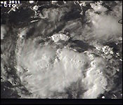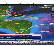
 Tonight, eyes across the country are on a tropical wave that's moving across the waters southeast of Belize and showing strong signs that it could become a storm by Saturday.
According to our plotting and estimates, the wave is about 560 miles east of Punta Gorda and moving west at 14 miles an hour.
The bad news tonight is that not that much is known about the inside of the storm. That's because the US Airforce Hurricane Hunter aircraft which was supposed to fly into the storm this afternoon ran into mechanical difficulties and that mission had to be aborted.
So there's no customary 6:00 pm update from the National Hurricane Center.
Chief Met Officer Dennis Gonguez told us what we do know at this time and that it should become a tropical depression by later this evening:
Dennis Gonguez, Chief Met Officer
"The active tropical wave entering the Western Caribbean has been slowly showing better signs of organization. Quite possibly a tropical depression could form later tonight or early tomorrow morning as the system heads into a more favorable conditions for development. The waves located some 500-525 miles east of Belize and is tracking towards the west about 10-15 miles per hour. It has
 slowed down a bit since yesterday; yesterday it was going about 15-20 miles per hour. It has slowed down to 10-15 miles per hour and that kind of hints towards of becoming more organized."
"The present track forecast if it continues on the present track and center of circulation develops - where we are seeing some rotation in the clouds the track will take it just over Northern Honduras and then southern Belize. That track over southern Honduras will sort of inhibit further development of the system and so if it continues on that track then we are looking at a tropical depression - a minor tropical storm come Saturday. We still need to pay attention to the system in the event that it tracks more further north and has more water to track over then it could develop into something even larger. But on the present track it looks like it could be a tropical depression or a minimum tropical storm."
We'll have more on this wave and another area of disturbance that's further to the east in our nightly weather report which is coming up later in the news…..


