
 Every year the National Geographic Society hosts Geography Awareness Week which is celebrated, November 13th thru the 19th.
A major highlight of this annual celebration is GIS Day, a global event that's intended to create awareness about geographic information system technology and the contribution it makes.
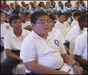
This year the theme is 'Discovering the World thru GIS', and at the Biltmore Hotel today, dozens of companies from both the government and private sector were sharing the technology, with hundreds of students.
The day is dedicated especially to students so as to expose them to the relevance of the technology in their education and daily lives.
Loretta Palacio - Managing Director, TBSL
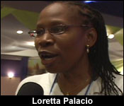 "Every year, countries celebrate GIS Day today by inviting their students to various companies. The utility companies, NGO's and Government Departments around the world are hosting students. So we wanted to get into this World GIS Day to expose our students, and this is why we pushed to get this done, because for the first time, Belizean students are joining the rest of the world to celebrate World GIS Day."
In Belize, many government ministries and departments as well as private sector organizations such as utilities, natural resource management organizations, agriculture, and other NGOs, like Healthy Reefs for Healthy People, UB's Environmental Research Institute and BTL are already using the technology.
Roberto Pott - Coordinator, Healthy Reefs
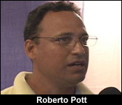 "It's a new tool in general for Belize, but it's been out there for a while, and they've been improvements trying to make the most out of the tool, and trying to see how best we can collect information. It's not just environmental information but also studying where the role that people play spatially in our environment. It's another criticism of the conservation community that a lot of times, people are ignored. It's one of the things that I always say that when you look at Belize City, the only beach that we can call a beach is Belizean Beach, but unfortunately, we have a dump placed right next to it. If we had looked at that and spatially planned out where we wanted to put our dump, our sewer ponds, and our beaches, I think we would have made better decisions."
Said Gutierrez - Wildlife Biologist, UB
 "What we do is a lot of work with mammals such as gibnuts, foxes, agouties and others. We're trapping these animals, and we are putting collars which have a radio transmitter that sends a signal to tell a particular location. That's what the animal is telling you, so on the display here, we have an array of instruments that we use to get that signal from the collar itself. So we stand with an antennae and pick up the signal, so we have a set of people doing that at the same time, we can see on the map where that animal is. So over a long period of time, say about a year, we can plot on a map and see exactly where the home range of the animal is."
Jesus Arnold - Planning Officer 1, BTL
 "This has helped our company a great deal by providing quick response in repairs or locating areas which need development. For the field technician, GPS coordinates in the field; normally this is what we use over there. As you can see, we have a bandicam behind you, and these record with the help of satellites, which is downloaded in real-time, and then its taken into the office to be processed for what we do differential corrections. We combine the base station information with the field information so that it can come out as accurate as about 10 to 15 centimeters. So if you are trying to find an underground infrastructure, we give you those coordinates, and the hand-held GPS, you can actually go out and pinpoint that an accuracy of 10 to 15 centimeters."