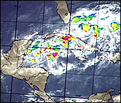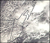
 Tropical depression number 9 passed over Belize last night into early this morning. The remains of the tropical depression are now near the lower Yucatan coast and they will slowly shift east and south through the weekend. The main impact from this system will be heavy rain over Central America- but according to our Chief Met Officer, there will be a cold front crossing over Belize early tomorrow morning that will break it up.
Dennis Gonguez - Chief Met Officer
"Tropical Depression #9 formed in the Bay of Campeche couple days ago and moved across the Yucatan Peninsula as it cross the land mass of Yucatan Peninsula it weakened and during the course of last night and this morning the remains of tropical depression #9 cross Belize and hence the increment weather conditions that we had yesterday and earlier this morning. The remains of tropical depression #9 continue moving eastwards, however, there is a cold front that's entering the Yucatan Peninsula tonight and eventually crossing Belize before dawn tomorrow. Cold air from this cold front will wrap around into the remnants of tropical depression #9 and that will impede its redevelopment for a couple of days and subsequent to that the cold front will lie on Sunday evening near to the northeastern Honduras and the remnants of tropical depression #9 will also be at the tail end of the cold front at near northeastern Honduras. The more tricky part comes on Monday  when the cold air breaks up over us and whatever is out there starts moving westwards us on Monday. We are not sure what it will be. Presently all the intensification models are forecasting that - it will not reach anywhere. Tropical depression #9 will not redevelop. However we still have to be cautious that something could happen at the tail end of the cold front because typically this time of the year that is the scenario that occurs - that we get systems developing at the tail ends of cold fronts. We start Monday afternoon with a more easterly flow and as a consequence whatever is over northeastern Honduras will start to head towards us. So we are looking at some changes come Monday, possibly just rains, another rainfall scenario and as I said the models are not intensifying the remains of tropical depression #9. They are not developing it into anything, however we still just have to keep an eye on it over the weekend."
So it will be a wet weekend - here's a more detailed forecast now in the nightly weather report.


