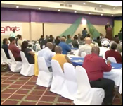
GIS, or Geographic Information Systems is technology used all over the world to track and collect important spatial data that assists in planning and development. Over the years Belize has taken steps to integrate GIS into different fields and today we found out at the 7th Belize ESRI user conference that the technology has made a big difference and promises to continue to do so.
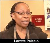
Loretta Palacio - TBSL, Managing Director
"What we are trying to achieve this year is to bring more leaders, more business people to understand the role of this technology and national development. This technology is important for National development, it goes across all industries and is used by countries for National Development and so when we are looking at flooding, when we are looking at emergency management, border issues, economic issues, bridges transportation systems it is all in a GIS so we are looking at agriculture, soil layer what kind of soil I sup north and why does sugar cane grow up north and why does citrus grow. We look at information like that on a map. Which communities should we address first when there is a flood threat and we can see population over the vulnerable areas. When you look at National Development we create a system of record because we are collecting data every day. A lot of digitization taking place. We are buying computers, we are buying servers, we are buying cell phones, and all kinds of devices in IT. We need to be able to collect data and what GIS does is create a common ground for all sorts of data to be analyzed for better decision making, to visualize for better decision making as well."
And while it is cutting edge technology, the experts say that due to mainstreaming and micro-processing, it won't burn a hole in your pocket.
Loretta Palacio - TBSL, Managing Director
"Cost is no longer an issue because recently what ESRI has done it has lowered the way it sells its software, meaning for over $1200 a year you can have access to a full suite of software. You are talking $1200 in Belize Dollars. That is just a first step where you have access to the dashboard, field applications. I think that ESRI has done a lot to make it affordable. Yes there are several software that you may need but it is a good start, so yes I think we are making strides in making it affordable."
The annual conference goes for two days.