Tonight, the Government is reporting that it has taken a major step to integrate technology in the way they do business.
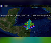
They're introducing a new computerized initiative called the Belize National Spatial Data Infrastructure. It is a collection of all known geographical data about the entire country, which were produced by experts from an extensive list of the public and private sector agencies. The GIS database will influence the way that the different government agencies tackle problems in the areas such as of tax mapping, property management, permit tracking, flood mitigation, and disaster management.
The project was officially unveiled this morning, and 7News attended to understand out how it will work. Daniel Ortiz has that story:
This is the Belize National Spatial Data Infrastructure. It is an electronic, GIS-based system, with online access that provides a map of Belize.
Now there are many maps of Belize. But what makes this system different is that it is a one-stop-shop for all currently available information about the country.
The Government agencies and their partners have been pooling all their technical information about Belize into one big database, where everyone with the relevant permissions can access it. Think of BNSDI as Google Maps, but specialized for Belize only.
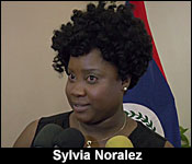
Sylvia Noralez - Spatial Data Administrator, BNSDI
"It's Google Maps, just for Belize, and the difference is that information is collected from organizations that produce this information. So, it's more accurate than what Google Earth has."
Kerry Belisle - CEO, Ministry of Natural Resources
"The BNSDI is a novel development for Belize, which involves an extraordinary partnership between 33 public sector institutions at present, and which harnesses state-of-the-art technology, including secure access via the internet, and powerful analytical capabilities."
Currently, the system is envisioned to be a powerful tool for planning, designing, and policymaking. One easily understandable use is in National Emergency and Disaster Management. Let's say, for example, a tropical storm is expected to hit Belize City, and the estimated amount of rainfall is known. The Government's technocrats at NEMO can then plug that information into the BNSDI, and run a simulation to see which parts of the city are flood-prone, and at-risk of being hardest hit:
Sylvia Noralez
"The BNSDI is a central databased for spatial information, and this information is basically for the layman or the Government to make informed decisions. Now, when I say informed decisions if you are living in a flooded, what this portal does, or what this infrastructure provides is it shows you that you're in a flood-prone area. Now, how it helps the Government now, is for them to have this information to do the planning, to overlay this information, to identify the vulnerable population when it comes to flooding, and then, respond to them. And so, it provides the data that is necessary for you to be identified and accessed."
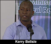
Kerry Belisle
"The spatial data that is, and will be in the BNSDI, Ladies, and gentlemen, will be useful for decision making in many areas. Just name a few, land use planning, natural resources management, which is especially critical as we depend on tourism and agriculture, disaster preparedness, response and recovery, which is especially relevant at this time of year, and climate change planning and mitigation, which is at the forefront of this BNSDI initiative, as our country is one of the most vulnerable in the world to the risks of climate change."
There is also a parallel climate-change initiative, known as the Climate Resilient Infrastructure Project, which has been in the planning stage for several years
That project will including upgrade works to a portion of the George Price Highway from Ladyville to Gardenia Village.

Yvonne Hyde - Chair, Project Steering Committee
"Approximately 5 years, aware of the effects of climate variability, and recognizing the potential impacts of climate change. We decided to partner with the World Bank for the preparation of the National Climate Resilient Investment Program, which we refer to As NCRIP. That was multi-sectoral, and based on consultation with the public, private, and NGO sectors, and the goal of the NCRIP is the reduce the vulnerability of the country to economic shocks, natural hazards and long-term effects of climate change. The objectives of CRIP are two-fold, to enhance the resilience of road infrastructure against flood risks, and the impact of climate change, and to improve the borrower's capacity to respond promptly and effectively to an eligible crisis or emergency as required. We will focus, in the project, on the rehabilitation of 16 miles of highway from the Vista Del Mar Junction to the Gardenia/Biscayne interface, on the Philip Goldson Highway, to reduce physical vulnerability to flooding and natural hazards."
Currently, there is a plan to create a secondary BNSDI for day-to-day use by the public:
Sylvia Noralez
"It is user-friendly. Anybody can go on the portal and download the information to use it and access it, to do whatever they need to do in terms of identifying a grocery shop, or the best restaurant to go to, and things of this sort. But for now, it is a government BNSDI. We will work toward a citizen's BNSDI in the future, but the focus is to identify and help government and non-governmental organizations to do more planning and more decision-making with GIS information."
As you saw in our story, the Chief Executive Officers from all the relevant government ministries all signed a memorandum of understanding on how they will get access to the BNSDI.Â
A week ago, the mayors from the 9 different municipalities country-wide also signed MOU's to be able to utilize this new system.