Turning now to news about this hurricane season, there is a weather
system, now known as Tropical Depression 14, that has quickly developed
over the last few days. Forecast models are indicating that it will
strengthen and bring heavy rains to Belize this weekend.
Several days ago, this system formed from a tropical disturbance in the
waters of the Caribbean Sea, just off the coast of Nicaragua. Since
then, it has strengthened to a tropical depression, and experts are
predicting that it could become a tropical storm by Sunday before it
makes landfall.
As a result, there is a tropical storm warning for coastal communities,
starting from the Honduras/Nicaragua border, and all the way to the
northern edge of the Yucatan Peninsula. Current forecast models suggest
that there is a possibility that Northern Belize could suffer severe
bad weather this weekend. That's if the storms make landfall on the
Yucatan Peninsula. But, whatever path the storm takes, Belizean
meteorologists are advising that there will be heavy rains all over the
country.
AN advisory from the National Emergency Management Organization says,
quote,
"Regardless of development or whether a potential landfall occurs
on the country, we need to be prepared for heavy rainfall and
possible flooding."
This afternoon, we spoke with Deputy Chief Meteorologist at the
National Met Service about the storm, and its forecast track:
 Ronald Gordon - Deputy Chief Meteorologist
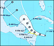
"The system that you're referring to, we've been monitoring it for the past
several. Initially, it came through the Caribbean. It was forecasted to
possibly become a depression and enter the North-west Caribbean Sea. And
this morning at 9 o'clock, the National Hurricane Centre upgraded it to a
[tropical] depression. As of midday, the system was located at latitude
15.4 degrees north, 80.0 west, and moving west at 18 miles per hour, with
winds of 35 miles per hour. That position is about 568 east southeast of
Belize City. The projected path for that system is for it to continue west,
at least for the next 12 hours. And when it gets to the northeast coast of
Honduras, it will curve to the west-northwest, and eventually northwest.
Most of the reliable models that I have looked at show the system making
landfall north of Belize. The cone of uncertainty that the National
Hurricane Centre has right now with the system has the lowest possible
track of that cone of uncertainty is just north of our borders. So, if the
system was to go extremely south, based on the uncertainty, it would make
landfall just north of Belize. The other extreme is that it goes through
the Yucatan Channel and avoids the Yucatan Peninsula altogether. So,
anywhere with that area, there is a possible landfall. However, these
tracks could change in time. So, we at the National Met Service will
monitor it carefully and see if there are any changes. But as I mentioned,
these are most likely scenarios at the moment, that it makes landfall north
of the country."
"If the system takes the most southerly track, if it goes on the
southern periphery of that cone, it will reach near enough to us for
the northern parts of the country to get some gusty winds from that
system. And it is likely that most of the country will get some heavy
rainfall from this system. Forecast models are indicating up to about 2
to 3 inches, with possible higher amounts, especially in the north of
the country. If this system does make landfall on Yucatan, it should be
late Saturday evening. So, even on Saturday, we'll start having more
rainfall from this system, as it approaches and moves just north of us,
based on the current forecast. The districts of Orange Walk and Corozal
will be the districts nearer to the centre, of where the system makes
landfall. However, the rainfall associated with a tropical system
doesn't always happen near the centre. So, my advice is for the
residence of the entire country to be on the alert and look out for the
possibility of flooding."
The latest 6:00 pm advisory says the "DEPRESSION is SHOWING SIGNS OF
GETTING BETTER ORGANIZED and is EXPECTED TO BECOME A TROPICAL STORM ON
FRIDAY. Right now the MAXIMUM SUSTAINED WINDS Are 35 miles per hours as
it moves west at 17 miles per hour. It is expected to approach the east
coast of the Yucatan Peninsula on Saturday and the center is then
expected to cross the Yucatan Peninsula on Saturday night. The National
Hurricane Center warns that the system could be near or at hurricane
strength when it reaches the Yucatan Peninsula of Mexico late Saturday.